SIGN UP
FOR DISCOUNTS, NEWS AND EVENTS BY EMAIL
Visit Albuquerque prohibits users from downloading images from our website.
Please use our media library for downloadable images and usage rights.![]()

This spectacular day trip begins 23 miles northwest of Bernalillo where NM 550 intersects NM 4. Follow NM 4 north through San Ysidro, a classic Spanish colonial farming village with a restored adobe church, to Jémez Pueblo. The road skirts the edge of the village of Walatowa, which means “The Place.” The Jémez are famous for their red-clay pottery. The Pueblo is off-limits but don’t be bashful about stopping and knocking on the doors of residence-galleries along the road.
When the Spanish arrived in 1541, some 62 major towns and 30,000 people comprised the Hemish (Jémez) homeland. Three-to four-story pueblos lined the mesa tops like stone fortresses. Over the decades, the Spanish consolidated the surviving Hemish into two villages with mission churches. Now, only Walatowa remains. The museum in the Walatowa Visitor Center tells the story of the Hemish people with displays of artifacts, pottery, graphics and a pueblo model.
For one of the most spectacular five-mile drives in New Mexico, continue north on Hwy 4 and take the NM 486 turnoff. The narrow lane winds past tiny farmsteads along the Guadalupe River. The mesa’s colorful layer-cake strata slope gently toward the river, then the canyon enters a hard strata of granite. Abruptly, the slopes become near-vertical cliffs of stunning red rock. In the 1920s, a logging railroad cut two tunnels in the granite cliffs. Below, the river tumbles over car-sized boulders through the serpentine canyon.
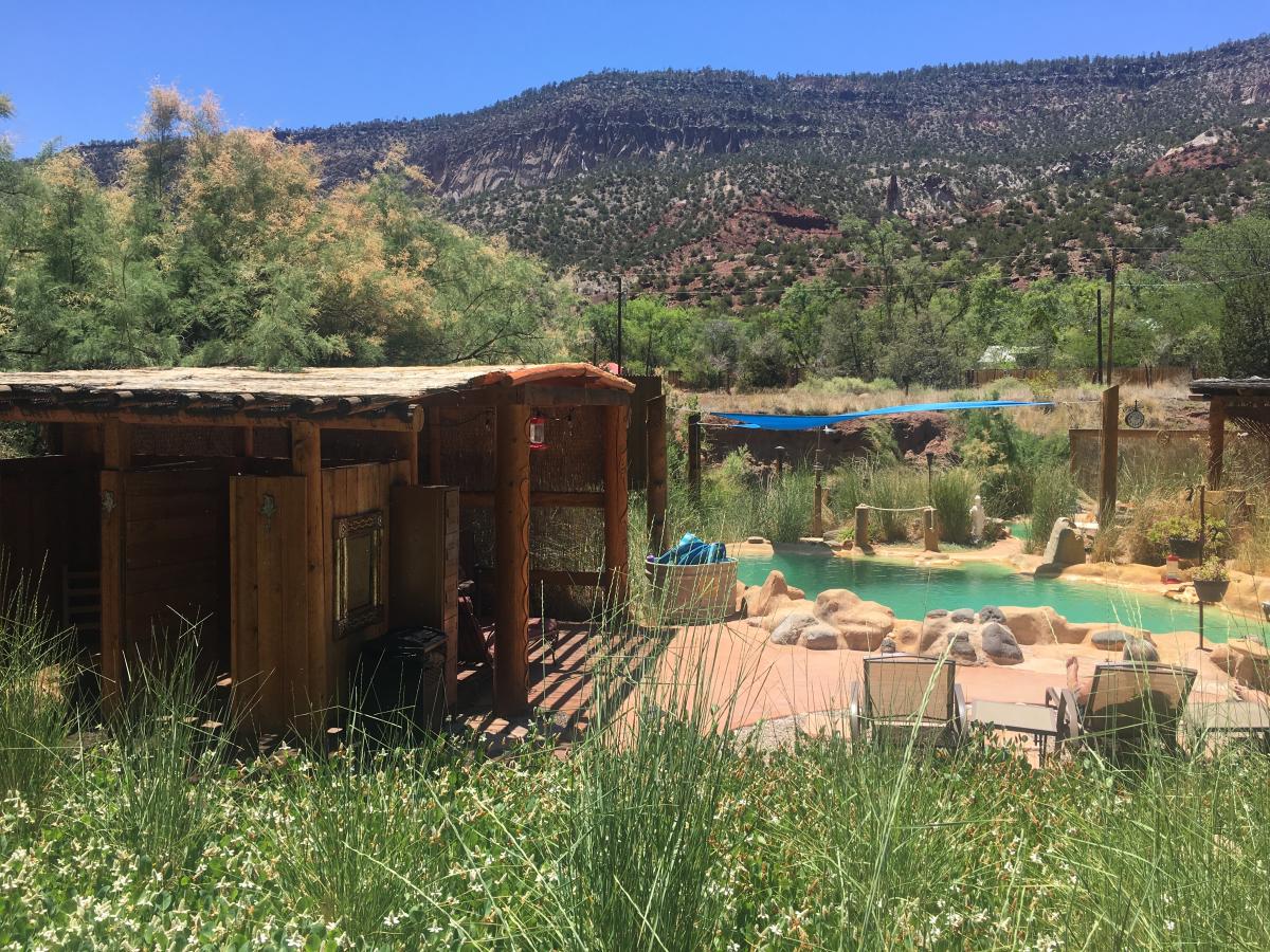
The scenic byway winds beneath towering cliffs in Cañon de San Diego and follows the cascading Jémez River, one of the state’s premier trout streams. The historic village of Jémez Springs, which dates back to the 1860s, is your only chance for a warm meal, a latte and pastry, shopping and gallery browsing. If you’re ready to relax, the modernized Jémez Springs Bathhouse, originally built in 1870, offers soaks and massages.
The ancestral Jémez people liked hot water as well and built a large pueblo they called Giusewa, “Place of the Boiling Waters.” The Spanish conquered the pueblo and built the massive stone San Jose de Los Jémez Mission. Jémez State Monument preserves the ruins of the pueblo and church at the northern edge of town. Across the street, the visitor center provides maps and information for the Valles Caldera National Preserve.
Before leaving town, you can grab lunch at one of the local cafés or restaurants along Highway 4.
One mile north of town, another spring pours across the Jémez River and forms Soda Dam. Like layers of an onion, the minerals built up to create a domelike deposit that spans the narrow gorge, except where the river cuts through. Four miles father north, Battleship Rock, a bare volcanic ridge, rises above the river like a ship sailing through the canyon.
At La Cueva, Amanda's Country Store sells snacks and fishing supplies. NM 126 forks west to Fenton Lake, a small state park 8 miles away, and continues for 30 miles through the Santa Fe National Forest to Cuba. The middle 20 miles are unpaved and closed in the winter. At Cuba, you can loop back on NM 550 to Albuquerque.
Continuing on Hwy 4, the Scenic Byway turns east at La Cueva and climbs through ponderosa forest to the mesa top and past groves of aspens with stately white trunks. At the Jémez Falls Campground, an easy .5-mile loop hike leads to Jémez Falls, a 70-foot plunge through a narrow gap in the granite bedrock.
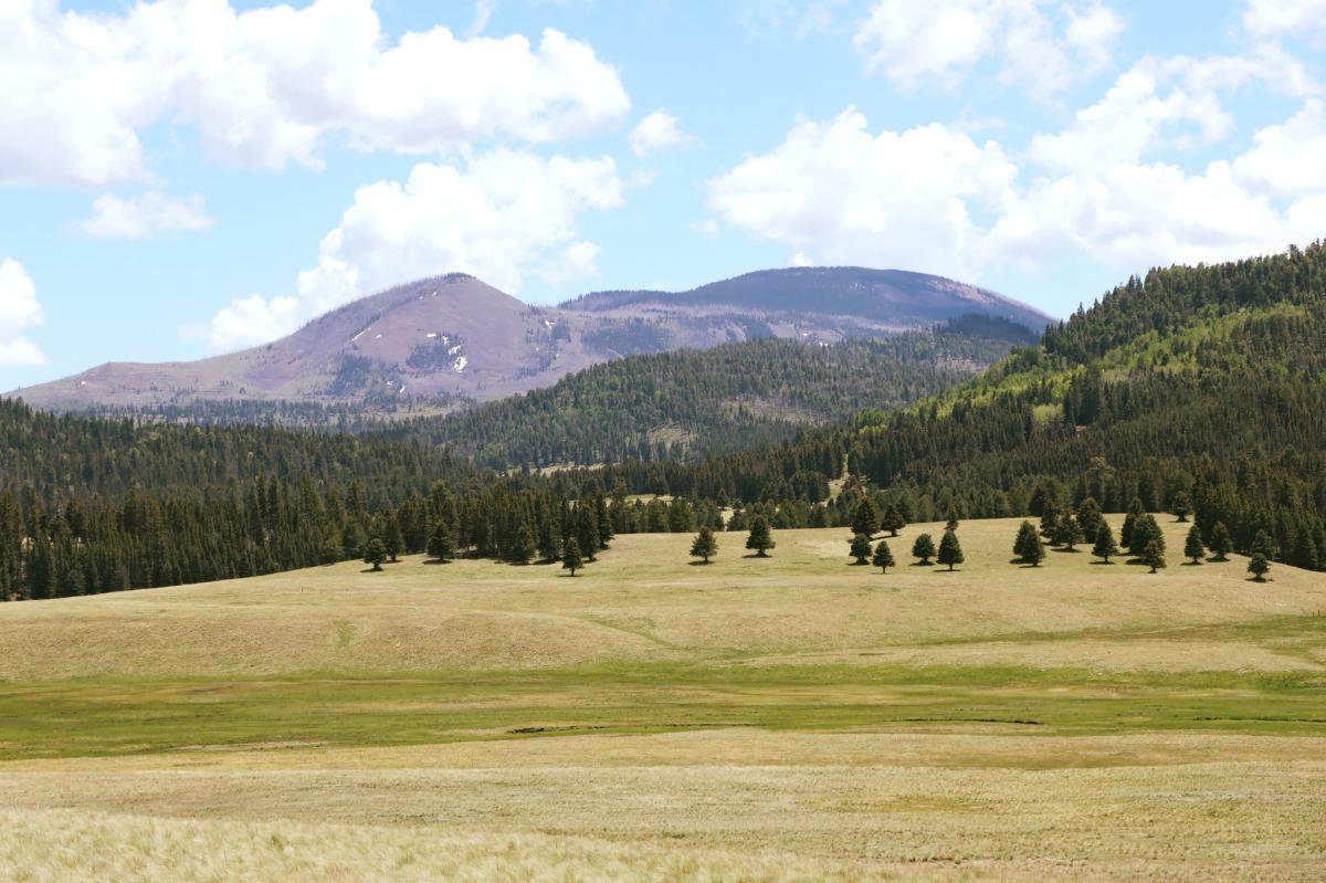 Photo Credit: Facebook
Continue another 5 miles to the Valles Caldera National Preserve. The park covers 89,000 acres of the massive collapsed volcanic domes and peaks that erupted 1.25 million years ago and formed the spectacular features of the Jémez Mountains. Two short trails lead into the forest and valleys from roadside trailheads and vistas overlook the geological wonder, but most is not open to the public except by prior arrangement.
To return to Albuquerque, backtrack on NM 4. Or continue east to Bandelier National Monument, Los Alamos, Santa Fe and Albuquerque via I-25.
The city of Albuquerque sits at a mile above sea level (5,000-6,000 ft. elevation) and has a high-desert... More
Albuquerque has fun for all ages, see our family fun page to learn more! More

Looking for discount hotel rates in Albuquerque, New Mexico? Albuquerque is home to legendary... More