
There’s a reason New Mexico is known as the Land of Enchantment, and Albuquerque’s high desert landscape and varying terrain offer hiking trails with some of the most enchanting views and treks in the state.
With shaded bosque paths along the Rio Grande, otherworldly volcanic terrain, intertwining dirt trails in the foothills of the Sandia Mountains, and a complex trail system suited for all skill levels in the Cibola National Forest, hiking in and near Albuquerque should be at the top of your to-do list.
If you’re itching for some fresh air and awe-inspiring treks, look no further. We’ve put together a list of some of Albuquerque’s best hikes with some of the best views.
Be careful, be prepared and do your research before embarking on a hike. This helpful hiking-safety guide from the National Park Service is a great resource and reminder for hikers of any level!
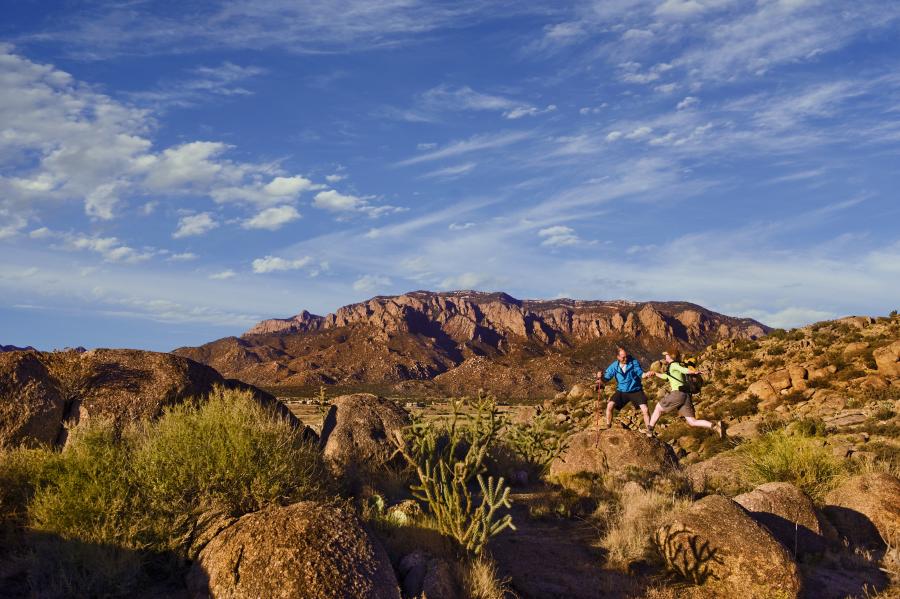
The Sandia Mountain Foothills
The Sandia Mountains border Albuquerque on its eastern edge, with their open space foothills accessible from anywhere in the city in just minutes. The Sandia Foothills Open Space is made up of approximately 2,650 acres, featuring miles and miles of intertwining trails open 365 days a year. To find a more comprehensive list of Trailhead access points head to cabq.gov.
Foothills Trail 365
One of the best and most vast trails to tour the Sandia Foothills, the 365 trail is 12.7 miles long and runs parallel to the ridgeline at the base of the mountains. This trail can be accessed from many of the foothill trailheads including Embudito Trailhead, Piedra Lisa Trailhead, Menaul Trailhead, and Embudo Canyon Trailhead. Running from Montgomery Blvd. to the base of Sandia Peak Aerial Tramway, Trail 365 can be hiked in either direction and offers a variety of steep slopes, flat terrain and beautiful views.
Embudito Trail 192
A local favorite, Embudito Trail offers six miles of intermediate to difficult terrain, leading to the South Crest Trail. Best explored in the warmer spring and summer seasons, this out and back features an array of wild flowers and a variety of scenery including both desert landscape and rich green forest. The upper portion of the trail should be explored with caution in the winter, when snowpack is likely.
Lower La Luz Trail
One of the best known trails in the Sandia Mountains, the La Luz Trail runs from the base of the Sandia Peak Tramway, all the way to the top of the Sandia Crest. The lower portion, beginning at the base of the Tram, is one of the most scenic trails in the foothills open space - offering views of the city from a multitude of vantage points. Make this hike as long or as short as you want, and enjoy the scenery from every angle. See below in the Sandia Mountains/Cibola National Forest section of this article for more information on the entirety of the La Luz Trail.
Grassy Hills Loop
This nearly four-mile loop explores small hills and easy, dirt-packed trails popular with day hikers and trail runners. Intersecting with many of the other trails in the Sandia Foothills, a hiker can easily make this loop shorter or longer as desired. The wide open landscape of the foothills makes it easy to keep track of where you are and where trails connect. Enjoy close up mountain views in combination with panoramic vistas of the city on this loop, beginning at the Cottonwood Springs Parking area and also accessible at the Elena Gallegos Picnic area.
The Sandia Mountains/Cibola National Forest
Beyond the Sandia Mountain Foothills, on the eastern face of the mountains, resides a hiker’s paradise. The Cibola National Forest in the Sandia Mountains is abundant with clearly marked trails, varying in difficulty for everyone from the beginner or family to the advanced hiker.
There are a multitude of other trails to explore in the Sandia Mountains and Cibola National Forest. SandiaHiking.com/trailguide and fs.usda.gov are both great resources. To access any of the trailheads and trails listed in this section, head East on I-40 from Albuquerque, take the Tijeras exit, travel north on Highway 14, and make a left onto the Sandia Peak Scenic Byway (Highway 528).
Cienega Canyon Picnic Site & Interpretive Trail
Ideal for families with small children, and accessible to hikers using mobility devices, this trail and picnic area features streams and small bridges throughout the well-maintained path. The easy, interpretive trail offers educational opportunities along the way, and winds around the shady, green, cool picnic area including tables and grills.
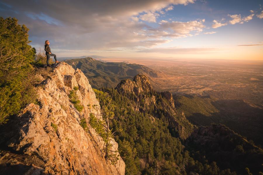
La Luz Trail
One of the most challenging and best known trails in the Sandias, La Luz takes hikers nearly 9 miles one way up the eastern face of the Sandia Mountains, from the base to the crest. Although one of the most popular trails in the mountain range, the 3,200 foot vertical climb comes with challenging terrain, and hikers should be prepared with water, food and time to complete the hike before dark. La Luz features terrain ranging from high-desert dirt-packed trail, to rocky scrambles, and dense forest in between.
To take this hike as a 9-mile trek, hikers can make the climb up the mountain to the crest, and ride the Sandia Peak Aerial Tramway back down the mountain. If choosing this route, you’ll want to make sure to leave a car at the Tramway parking lot at the base of the mountain, and begin your hike from the trailhead in that parking area. Some hikers prefer to make the 15-17-mile round trip, but make sure you are prepared for the trail’s mileage and challenges along the way.
La Luz is best hiked in the fall, summer and late spring, as parts of the trail are impassible in the snow. Always check the weather and conditions before embarking on the full La Luz Trail hike.
The Sandia Crest Trail
The Sandia Crest Trail traverses the entire range of the Sandia Mountains and can be hiked in either direction. While the full 22.1-mile shuttle hike can be done in-full by skilled hikers, there are many routes that offer variation in length, and difficulty.
The northern end of the trail is located at the Tunnel Springs Trailhead while the southern end is located at the Canyon Estates Trailhead. Some hikers choose to tackle this trail in one long day, and others make it a two-day backpacking route, with a car shuttle set up.
Many of the most popular trails in the Sandia Mountains, and all of the routes featured below in this section, are portions of or connections to the main Sandia Crest Trail.
North Crest Trail
North Crest Trail offers spectacular views, lots of tree-covered and shaded paths, and access to many other trails in the Cibola National Forest. The North Crest Trailhead can be found just north of the Sandia Crest parking lot. It starts by skirting the fence that encloses the radio towers at the top of the Crest, and then opens up into secluded trail and connections to many other paths. Be sure to pay attention to trail signs, and keep track of your turns, so you can find your way back to the parking lot at the end of your hike.
10K Trailhead
10K North and 10K South Trailheads can both be found on Scenic Byway 536, on opposite sides of the highway, both offering fantastic hiking options.
10K Trailhead gives access to 10K Trail 200 going North, ending at the Del Agua Overlook on North Crest Trail 130, while 10K South Trailhead ends at the junction of Tree Spring Trail 147 and South Crest Trail 130.
Either direction you choose will lead you to an out and back, moderately difficult trail, plentiful with wild flowers in the spring and summer seasons. The trail begins with shade and thick forest, and opens up to beautiful views in either direction.
Tree Springs Trailhead
The Tree Springs Trailhead offers access to a beautiful, moderately challenging, 3.75-mile hike to the Sandia Crest, the Sandia Peak Aerial Tramway, and the restaurant Ten 3. From the trailhead, take the Tree Springs Trail about two miles, until you come to the trail’s official end point, where you can then access the Sandia Crest Trail (to access the Tram and the peak), or continue onto the 10K Trail (will not give you access to the Tram).
The Rio Grande Bosque Trails

One of Albuquerque’s most unexpected and incomparable features, is the Paseo del Bosque Trail. The multi-use trail runs the full length of the city, from the north to the south edges of the metro area through the Rio Grande’s cottonwood bosque (forest). With 16 miles of paved pathway uninterrupted by roadways, the Paseo del Bosque Trail is a popular with visitors and locals alike, all year round. For information about trail access throughout the city, visit cabq.gov.
If the sun-soaked paved pathway isn’t your style, take one of the many dirt trails that break off from the main Paseo del Bosque Trail, into the Rio Grande Valley State Park. These dirt trails intertwine, intersect and connect with each other along the riverside throughout the open space. For more information about the State Park and river access visit cabq.gov.
West Mesa Hiking
Albuquerque’s western horizon features several uniquely southwestern features, making the West Mesa a dramatic backdrop for your next hike. Petroglyph National Monument encompasses the 17-mile long volcanic basalt escarpment, with a variety of trails and recreational areas throughout.
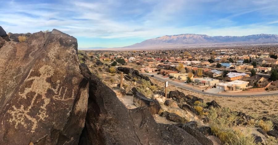
Petroglyph National Monument
Petroglyph National Monument offers a glimpse into Albuquerque’s deep rooted history, protecting many archeological sites and an array of volcanic rock featuring an estimated 24,000 images carved by Ancestral Pueblo peoples and early Spanish settlers.
With four main hiking trails, three of which offer petroglyph viewing, this area is great for hikers of all ages and skill levels. The four trails vary in length and difficulty, and detailed guides are available at the visitor center.
Some of the most popular trails at Petroglyph National Monument are the Boca Negra Canyon and the Volcano Day Use Area.
Paseo De La Mesa Trail
Paseo De La Mesa Trail skirts the volcanoes on Albuquerque’s west side and offers 360-degree views of the metropolitan area and the west mesa. The actual trail includes four miles of paved path, uninterrupted by roadways, but many other shoot-off trails and intersections in the trail network offer a multitude of hiking experiences. In fact, the network of trails connected to the Paseo De La Mesa Trail can offer up to a 20-mile hike. Fairly flat, this trail is an easy trek, but offers little shade.
Hiking Trails Near Albuquerque
Albuquerque is surrounded by several other notable hiking locations, all within just 1-2 hours of the city.
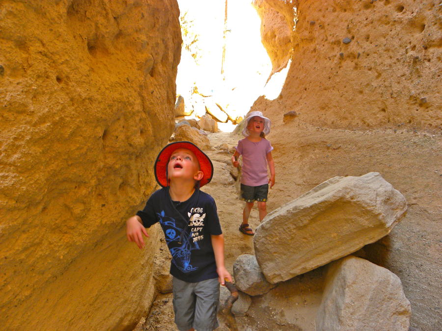
Kasha-Katuwe Tent Rocks National Monument
For slot canyons and visually-incredible rock formations, head to Kasha-Katuwe Tent Rocks National Monument, only an hour outside of Albuquerque. The hiking trail traverses through deep canyons, and a multitude of cone-shaped tent rock formations, the products of volcanic eruptions that occurred 6 to 7 million years ago.
Jemez Springs
Less than 2 hours from Albuquerque, the Jemez Springs area offers hiking trails, picnic and-day use areas, and natural hot springs fit for the whole family or any level of hiker. Visit the Jemez for some relaxation and soaking, and explore the Santa Fe National Forest with hiking trails throughout the mountainous terrain. Valles Caldera National Preserve, Las Conchas Trail, East Fork Trail, Battleship Rock, and the Gilman Tunnels areas are some popular trails and hiking areas around Jemez Springs.
Bandelier National Monument
Take the quick drive from Albuquerque to Bandelier National Monument for a combination of hiking, history, and culture. Bandelier features ancient pueblo dwellings dating back 10,000 years, archeological cavates, and petroglyphs among their paved and unpaved trails.